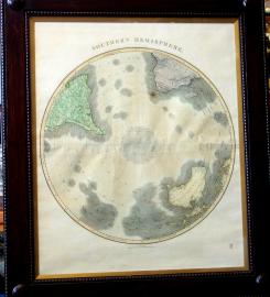
Published by the important map maker John Thomson. A fascinating look at history is this early 19th century map of the southern hemisphere. Note the depiction of Australia still called New Holland and Tasmania as Van Diemen's land as they were named in 1618 by Abel Tasman. The Cape of Good Hope and Cape Horn with the straits of Magellan are clearly marked and are notably accurate.
The most interesting aspect of this map is the continent of Antarctica, as yet undiscovered in 1814. Since the earliest voyages of pacific discovery in the sixteenth century, explorers had been seeking the great southern continent; terra australis incognita, first postulated by the ancient Greeks. For two hundred years European navigators searched in vain for this fabled land mass.
On his second voyage of discovery, Captain Cook was instructed to seek out and confirm the southern continent's existence. He penetrated to 71 degrees south latitude before proclaiming that no continent could possibly exist further south. This map published one of Cook's only errors by showing nothing but ice below 71 degrees south latitude. It would be another half century before man would set foot on the Antarctic continent.